© 2013 Oceanic Imaging Consultants, Inc.
Service + Software for Seafloor Mapping

OIC Projects
1. Kaimalu O Hawaii –Terrorism Preparedness Exercise, Pier 19 Honolulu Harbor, Hawaii
2. High Resolution Sidescan/ Bathemetry Survey of Waiau Cooling Basin, Honolulu, Hawaii
3. SeaWater Air Conditioning Pipeline Route, Bora Bora, French Polynesia
4. SeaWater Air Conditioning Pipeline Route, Curaçao, Netherlands Antilles
5. Santa Monica Basin Cable Route Survey, Santa Monica, California
6. Atlantic-Mediterranean
Segment Submarine Cable System, Principality of Monaco
7. STARS – NAVFAC Deep-Towed Sonar Survey off the Coast of California
8. Chevron Typhoon Survey,
Gulf of Mexico
9. NOAA Ordnance Reef Survey,
Five Miles off Pokai Bay, Waianae, Hawaii
10. Shell Shallow Water Geohazard Survey, Beaufort Sea, Alaska

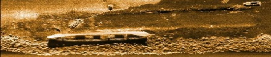
Project 7.
STARS – NAVFAC Deep-Towed Sonar Survey
off the Coast of California
Project
Owner: Naval Facilities Engineering Command (NAVFAC)
Prime: No
Subcontract: Yes / Science
Applications International Corporation (SAIC)
NAVFAC selected Science Applications International Corporation (SAIC) to acquire high-resolution bathymetry, sidescan, and sub-bottom data at a depth of 3500 feet off the coast of California. SAIC subcontracted OIC to execute the deep-towed survey, which required 24 hour operations for eight days and used four OIC personnel to manage the data acquisition and processing. The sonar system employed for the survey was the Teledyne Benthos C3D interferometric sonar system with sub-bottom profiler.
Auxiliary sensors included an Ixsea Octans motion sensor, an FSI pressure sensor, and a sound velocimeter. OIC’s GeoDAS software was used to simultaneously log the incoming sidescan, bathymetry, and sub-bottom data; OIC’s CleanSweep software program was used for data processing and final product generation. Using the post-processing tools available in CleanSweep, we were able to easily handle several technical challenges inherent of deep-towed surveys.
Due to the innate difficulty of acquiring accurate navigation data for a vehicle being towed with kilometers of cable, there was significant and variable along- and across-track mismatch between adjacent survey lines. A tool unique to CleanSweep, called InterNav, allowed us to match features in post-processing and re-navigate the survey data to produce an accurate and coherent final mosaic. Another issue encountered in this dataset was the presence of heave-like artifacts in the bathy data. Depth values are typically calculated using the depths below the towfish, which are determined by the mapping system and then adding the depth of the towfish as measured by a depth sensor located in the towbody. Artifacts existed in the data due to the effects of surface waves on the depth sensor measurements and possibly the inability of the depth sensor to capture the vertical motion of the towfish. Because the C3D tow-body was equipped with an Ixsea Octans motion sensor with heave measurement capability, we developed an alternate way of determining towfish depth. Essentially, we smoothed the depth sensor data in order to remove the high-frequency variations associated with surface waves and vertical motion of the towfish.
Next, we ran a high pass filter on the heave data in order to isolate just the high-frequency vertical motions of the towfish. We then combined the two values (heave and depth) and produced a new towfish depth time-series. This method was effective in reducing or eliminating much of the artifacts in the data.
After finalizing the data processing back at OIC headquarters in Honolulu, final products were delivered to SAIC in the form of XYZ bathymetry grid, sidescan mosaic geotiff, target report, and ArcGIS format bathymetry grids, hillshade images, and contours.