© 2013 Oceanic Imaging Consultants, Inc.
Service + Software for Seafloor Mapping


BACKGROUND
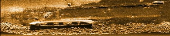
Oceanic Imaging Consultants, Inc. was founded in 1993 as a spin-off of research completed for the Office of Naval Research at the University of Hawaii. Today, OIC is a full-service software company that provides custom seafloor mapping software solutions and services to military, government, private, and academic clients worldwide. Some of our most popular hydrographic software systems are GeoDAS, ROVer’s Eye, OIC-Class, and PipeTrack. We are proud that our staff expertise is the result decades of hands-on surveying experience.
About Oceanic Imaging Consultants, Inc.
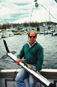
Dr. Tom Reed
President,
Oceanic Imaging Consultants Inc.
Tom Reed, President and Founder Oceanic Imaging Consultants, Inc., received his undergraduate degrees in Economic Geology from Harvard and Massachusetts Institute of Technology in 1982, and his Ph.D. in Marine Geology and Geophysics from the University of Hawaii (UH) at Manoa in 1987. His research at UH included development and programming of automated techniques for analysis and mapping of the seafloor with side scan sonar. This research was performed largely for the Office of Naval Research in association with the UH SeaMARC II Sidescan Sonar Seafloor Mapping Program. In 1993, Dr. Reed founded Oceanic Imaging Consultants, Inc. to answer the growing need for commercially available seafloor mapping software, services, and systems. Dr. Reed’s research interests include acoustics, remote sensing and statistics as applied to problems in marine geology and geophysics.
Today, the Oceanic Imaging Consultants team is made up of a dynamic and enthusiastic group of individuals who love what they do, and where they live. Most of our employees are proficient in a variety of hydrographic survey-related skills, and enjoy the challenge of bringing superior knowledge and expertise to their work. Please see our OIC Careers page for opportunities to work in this fast-paced and exciting environment.