© 2013 Oceanic Imaging Consultants, Inc.
Service + Software for Seafloor Mapping

OIC Projects
1. Kaimalu O Hawaii –Terrorism Preparedness Exercise, Pier 19 Honolulu Harbor, Hawaii
2. High Resolution Sidescan/ Bathemetry Survey of Waiau Cooling Basin, Honolulu, Hawaii
3. SeaWater Air Conditioning Pipeline Route, Bora Bora, French Polynesia
4. SeaWater Air Conditioning Pipeline Route, Curaçao, Netherlands Antilles
5. Santa Monica Basin Cable Route Survey, Santa Monica, California
6. Atlantic-Mediterranean
Segment Submarine Cable System, Principality of Monaco
7. STARS – NAVFAC Deep-Towed Sonar Survey off the Coast of California
8. Chevron Typhoon Survey,
Gulf of Mexico
9. NOAA Ordnance Reef Survey,
Five Miles off Pokai Bay, Waianae, Hawaii
10. Shell Shallow Water Geohazard Survey, Beaufort Sea, Alaska

Project 2.
High Resolution Sidescan/Bathymetry Survey of Waiau Cooling Basin, Honolulu,
Hawaii
Project Owner: Hawaiian Electric Company, Inc.
Prime: Yes
Subcontract: No
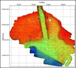
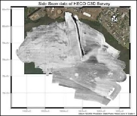
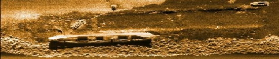
In 2007, Hawaiian Electric Company, Inc. contracted OIC to provide a bathymetric map and difference analysis of the areas offshore of the HECO Waiau power plant to determine whether the cooling basin needed to be dredged.
OIC conducted a high resolution survey of the waters offshore of the HECO Waiau power
plant using their 21’ survey launch and C3D interferometric sonar
to produce maps
of both bathymetry and imagery at sub-meter resolution.