GeoDAS for Forward-Look Sonar
GeoDAS-FLS (Forward-Look Sonar) controls and acquires data from the Ultra Electronics high-frequency wide-band forward looking sonar system. The side-by-side bathymetry and imagery displays provide obstacle avoidance capabilities and overall environmental awareness. In addition to the acquisition and playback module, GeoDAS-FLS includes target analysis capabilities and provides a superior working environment for vehicle operators, particularly in low-visibility environments.
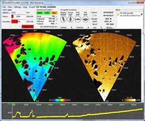
The GeoDAS-FlS GUI provides a customizable interface for acquiring and analyzing your forward-look data. The main GUI component is the side-by-side bathymetry and imagery sector displays. Beneath the sectors displays is a bathymetry profile for the region ahead of the vehicle.
Graphical User Interface
- Logging controls with system/network status indicator
- Navigation and attitude information
- Imagery and bathymetry processing
- Scan-line waterfall display
- look-ahead bathymetry profile
System Control Interface
GeoDAS-FLS allows operators to directly control the sonar acquisition settings. Specific controls include:
- Range and sector width
- Ping Interval
- Pulse length
- Pulse amplitude
- Time Varying Gain control (TVG)
- Apply pitch and roll corrections
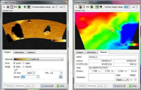
Target Analysis
- Mark bathymetry or imagery targets
- Process target images post-capture
- Target mensuration capabilities
- Customize feature categories
- Output to target database


