© 2013 Oceanic Imaging Consultants, Inc.
Service + Software for Seafloor Mapping

OIC Projects
1. Kaimalu O Hawaii –Terrorism Preparedness Exercise, Pier 19 Honolulu Harbor, Hawaii
2. High Resolution Sidescan/ Bathemetry Survey of Waiau Cooling Basin, Honolulu, Hawaii
3. SeaWater Air Conditioning Pipeline Route, Bora Bora, French Polynesia
4. SeaWater Air Conditioning Pipeline Route, Curaçao, Netherlands Antilles
5. Santa Monica Basin Cable Route Survey, Santa Monica, California
6. Atlantic-Mediterranean
Segment Submarine Cable System, Principality of Monaco
7. STARS – NAVFAC Deep-Towed Sonar Survey off the Coast of California
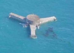
8. Chevron Typhoon Survey,
Gulf of Mexico
9. NOAA Ordnance Reef Survey,
Five Miles off Pokai Bay, Waianae, Hawaii
10. Shell Shallow Water Geohazard Survey, Beaufort Sea, Alaska

Project 8.
Chevron Typhoon Survey, Gulf of Mexico
Project Owner: DWS International
Inc.
Prime: No
Subcontract: Yes / Science Applications International Corporation (SAIC)
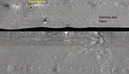
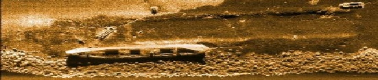
DWS International Inc. / SAIC contracted OIC for data acquisition and processing for a survey conducted in the deepwater Gulf of Mexico. The survey was conducted to investigate the area where Chevron’s typhoon tension leg platform used to be stationed. When Hurricane Rita struck the area, the platform lost it’s moorings, capsized, and drifted nearly 100 miles away.
OIC’s GeoDAS software was used to acquire and process data from EdgeTech 2200DW dual frequency sidescan sonar and sub-bottom profiler mounted on SAIC’s FOCUS deep-tow survey vehicle. Williamson and Associates’ 120kHz deep-tow sidescan data were also acquired to compare data quality with SAIC’s 120 and 410 kHz data and SAIC’s dual frequency system was proven to produce imagery with higher clarity and details.