Overview
Acquisition
Display Configuration
Sidescan Processing
Bathy Processing
Targeting
Mosaicking
Survey Management
Advanced Survey Management
Mission Products
GeoDAS Modules
Supported Sensors
Specification Sheet
Review any OIC product by selecting it from the menu below
Choose a Product
GeoDAS
GeoDAS Multibeam
GeoDAS Lite
GeoDAS-Desktop
GeoDAS-SDV
OIC Navigation & Altitude Processing
OIC Cleansweep
OIC Toolkit
ROVer's Eye
OIC Pipetrack
OIC Class
HullSweep
GeoDAS-FLS
Choose from the dropdown menus below to learn about OIC supported sensor types
Click on the dropdown menu below to find out more about the services OIC offers.
Choose a Task
Data Processing
Survey Management/Execution
Training In-house/At Sea
Programming
Home
»
Products
»
Software
»
GeoDAS
GeoDAS
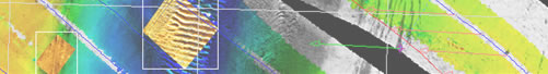
ADVANCED SURVEY MANAGEMENT
Through its
Advanced Survey Management
utilities, GeoDAS allows users to
select areas of interest
from
global maps
, hone in on
vector & raster charts
,
load data from national databases
, define
survey bounds
,
waypoints
, and
run-lines
.
Read more about GeoDAS.
View a variety of data samples processed by GeoDAS.
Learn which sensors GeoDAS supports.
Download GeoDAS Spec sheets
HOME
PRODUCTS
SERVICES
DATA SAMPLES
SUPPORT
ABOUT OIC
CONTACT
Oceanic Imaging Consultants, Inc.
1144 10th Avenue, Suite 200 Honolulu, Hawaii, 96816-2442
Tel (808)539-3706 | Fax (808) 791-4075 |
info@oicinc.com
Privacy Policy
webmaster@oicinc.com