Overview
Supported Sensors
Specification Sheet
Review any OIC product by selecting it from the menu below
Choose a Product
GeoDAS
GeoDAS Multibeam
GeoDAS Lite
GeoDAS-Desktop
GeoDAS-SDV
OIC Navigation & Altitude Processing
OIC Cleansweep
OIC Toolkit
ROVer's Eye
OIC Pipetrack
OIC Class
HullSweep
GeoDAS-FLS
Choose from the dropdown menus below to learn about OIC supported sensor types
Click on the dropdown menu below to find out more about the services OIC offers.
Choose a Task
Data Processing
Survey Management/Execution
Training In-house/At Sea
Programming
Home
»
Products
»
Software
»
GeoDAS-MB
GeoDAS-MB
OVERVIEW
GeoDAS-MB is
multibeam-specific
GeoDAS software from OIC.
Bathy processing tools
,
Target
and
Event tracking
, simultaneous
multibeam
and
sidescan data logging
, and
3D bathy display
are just some of the many standard features.
Find out about sensor support for GeoDAS-MB
Download GeoDAS-MB spec sheets
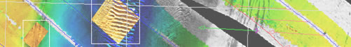
View a variety of data samples processed by GeoDAS-MB
HOME
PRODUCTS
SERVICES
DATA SAMPLES
SUPPORT
ABOUT OIC
CONTACT
Oceanic Imaging Consultants, Inc.
1144 10th Avenue, Suite 200 Honolulu, Hawaii, 96816-2442
Tel (808)539-3706 | Fax (808) 791-4075 |
info@oicinc.com
Privacy Policy
webmaster@oicinc.com