| |
|
| |
| |
 |
| Review any OIC product by selecting it from the menu below |
| |
|
|
 |
| Choose from the dropdown menus below to learn about OIC supported sensor types |
| |
|
|
 |
| Click on the dropdown menu below to find out more about the services OIC offers. |
| |
|
| |
|
|
|
 |
|
|
| Home »
Products » Software » OICToolkit |
|
| OICToolkit |
| |
OVERVIEW |
| |
 |
| |
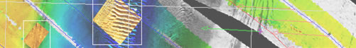
OICToolKit is a Unix-based, comprehensive post-acquisition processing system for correction, enhancement and mosaicking of your sidescan sonar imagery, interferometric bathymetry and multi-beam data. OICToolKit provides a complete suite of editing, processing and enhancement tools to turn raw data into geo-coded mosaics and DIMs for a wide variety of raster, vector and GIS outputs.
The OICToolKit provides a complete data processing environment that facilitates access to raw data files, while minimizing bookkeeping demands upon the user.
Ideal for large-scale processing requirements.
Graphical selection of data files and automatic generation of sonar data swath coverage maps allows intuitive matching of regions of interest to data to be processed, eliminating the need for paper logs or file-naming guesswork.
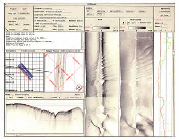
Data Processing
Our "point-and-click" interface allows easy definition of survey lines and line segments, so that you process only the data you need, when you need it.
The OICToolKit saves the process, not the temporary files, therefore adjustments are easy and there is no loss in fidelity nor processing penalty for last minute adjustments.
On-the-fly conversion utilities allow importing of data from a wide array of sensors.
Sidescan, interferometry and multi-beam data are all converted to OIC internal records, and processed similarly resulting in a vastly shortened learning curve. Once you can process one type of data, you can easily process any other. |
| |
|
| |
OIC TOOLKIT SYSTEMS SUPPORTED |
| |
Input Data |
| |
- EG&G/EdgeTech: 260, 380, DF-1O00, LC100, FS-AU
- MSTL: Sea Scan 150, 600, 1200
- Klein: T2000, 5000
- Datasonics SIS1000, SIS1500, SIS3000
- GLORIA, TOBI, QMIPS, CMAX, XTF
- SSI: SYS9, SYS120
- TAMU-TAMU
- SeaMARC 11/12
- Deepscan: 60, 120, 325
- Atlas Hydrosweep, SEABEAM
- Reson: Sea bat 8101,8102,8125,9001
- Simrad: EM 12, 300, 950, 3000
- AMS120, DSL 120
|
| |
Data Output |
| |
- OIC binary grid files, GeoTIFF
- netCDF grid files for GMT
- ASCII XYZ profiles or areas
- ERMapper, Arclnfo, AutoCAD-CS
- TIFF, TARGA, RAS, PCX, RLE, PS and more
|
| |
Please feel free to contact us for updates and additional information on ToolKit supported systems, by clicking here [Support>Contact]
|
| |
|
|
|