| |
|
| |
| |
 |
| Review any OIC product by selecting it from the menu below |
| |
|
|
 |
| Choose from the dropdown menus below to learn about OIC supported sensor types |
| |
|
|
 |
| Click on the dropdown menu below to find out more about the services OIC offers. |
| |
|
| |
|
|
|
 |
|
|
| Home »
Products » Software » GeoDAS-Desktop |
|
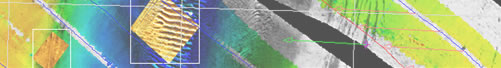
| GeoDAS-Desktop |
| |
FEATURES INCLUDES |
| |
- fully geo-coded sidescan imagery and bathymetry data with processing and enhancement options.
- Sidescan processing options include enhancement of image gain and contrast, suppression of beam-pattern artifacts, interactive bottom track editing, and an infinite variety of color maps.
- Bathymetry processing options include draft, tide and sound velocity correction, beam editing, and attitude bias and latency compensation.
- The Navigation and Attitude Processing module (OIC_NAP) allows import, reprocessing, and export of navigation and attitude data, cleaning spikes and interpolating gaps
- Datum conversion and re-projection: LON/LAT, UTM, SPCS, OSGB and more.
- Supports mosaicking of sidescan and bathymetry data at any resolution
- Export to image and GIS-ready formats: ERMapper, ARCInfo, ASCII, etc.
- Double-precision data storage and processing allows millimeter accuracy and resolution in mosaics.
|
| |
FORMATS SUPPORTED |
| |
- C-MAX Data format: (QMIPS)
- Datasonics SIS-1000, -1500, -1501, -3000 Data format: (OIC)
- EdgeTech DF 1000, 272-T, FS-Chirp Data format: (Raw)
- Klein 595, KL2000, KL5000 Data format: (Raw)
- MSTL Sea Scan 150-300-600-1200 Data format: (MSTiff)
- Reson SeaBat 9001, 8101, 8125 Data format: (6042)
- Simrad EM12, 1000, 300, 3000 Data format: (Raw)
- Tritech/SeaKing SKTF325, SKTF675 Data format: (Raw)
- Hypack Max
- SEG-Y
- XTF
- CODA
- Hypack Max
|
|
|