
© 2013 Oceanic Imaging Consultants, Inc.
Service + Software for Seafloor Mapping

Archive / 2006

(continued)
February 2006
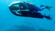
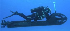
OIC has just completed sea-trials on GeoDAS-SDV, our new navigation, mapping and
obstacle avoidance system, tailor-made for swimmer delivery vehicles. GeoDAS-SDV
uses a waterproof GPS to acquire initial position fixes at the surface, then updates
navigation data once the vehicle is at depth by using information from an integrated
Doppler Velocity Log (DVL) and compass. For mapping, GeoDAS-SDV can be equipped with
single or dual-frequency sidescan, while for obstacle avoidance, a forward-looking
sector-scan sonar is incorporated. Users view the data on twin SVGA screens, and
interact with the system via a custom-built pair of 6-button touch-pads, allowing
control of range, gain, display mode and zoom. Hardware options include user-selection
of sidescan and forward-look sonars. Software options include ROVer’s Eye for 3D
real-time visualization in the survey, real-time mosaicking of sidescan or forward
look data, and display of survey track or mosaic over electronic nautical charts
(DNC, S-57, BSB, Transas, etc.).
February 2006
GeoDAS-PC News. OIC releases SmartSonar! Take the guess-work out of optimally tuning your sonar and multibeam. Under funding from CEROS (Centers for Excellence in Research in Ocean Science -) OIC has developed SmartSonar, the latest update to our GeoDAS software package. SmartSonar uses proprietary algorithms to automatically adjust sensor range and gains, allowing collection of optimally tuned raw sonar data, free from any clipping or saturation, even under wide variations in seabed geology. Display tuning is now also automated, providing optimal image correction and contrast enhancement in real-time. In addition, SmartSonar’s automatic target detection algorithms determine possible target locations during surveying, and alert the user. These tools dramatically simplify the survey data acquisition process, and assure greater overall quality control.
February 2006
AzulMar Research, LLC, of Port Republic, MD is now offering hydrographic
survey training using OIC software. For more information on the survey course, please
download their brochure by clicking here.
January 2006
Bermuda Biological Station for Research, Inc. To make room for the arrival
of their new, larger research vessel, the Bermuda Biological Station has contracted
OIC to perform a high resolution route survey in the waters around St. George, Bermuda.
OIC and BBSR staff performed the survey, using GeoDAS-LT and the Imagenex YellowFin
tri-frequency digital sidescan, producing decimeter-scale fully geo-coded imagery
for the survey area in two days.